Sites Prepared for Immediate Construction
Lot and Land Development in Naches for residential builds and agricultural operations
Undeveloped land requires clearing vegetation, removing topsoil from building zones, establishing drainage grades, and laying out utility corridors before construction crews arrive. All Valley Land Managment & Excavation provides full-service land preparation across Naches, coordinating phases from initial clearing through final grading so building permits can be issued without delays caused by incomplete site work. Developers and property owners use this sequenced approach to avoid rework when foundations, utilities, or access roads conflict with drainage patterns or soil conditions discovered mid-project.
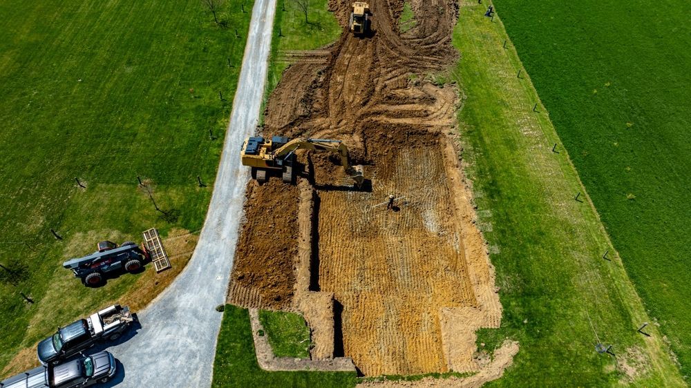
Land development starts with surveyed property corners and preliminary grading plans that identify building pads, roads, utility easements, and stormwater management zones. Clearing removes trees, stumps, and brush, while rough grading establishes positive drainage away from structures. Excavation follows for foundations, utility trenches, and roadbeds, with material either stockpiled for later backfill or hauled off-site depending on soil quality and project needs.
Schedule a property review to assess clearing requirements, soil suitability, and phasing timelines for your development plans.
Rough grading shapes overall site contours and drainage flow, creating building pads within specified elevation tolerances and sloping surfaces to move stormwater toward retention areas or natural drainages. Finish grading refines surfaces to final elevations around completed structures, prepares planting beds, and establishes slopes for landscaping or erosion control. Both phases require blade control and compaction management to prevent settling after construction traffic ends.
After land development completes, you'll see defined building pads level within inches across their footprint, access roads connecting to property entries without steep transitions, and swales or berms directing runoff away from construction zones. Utilities are stubbed to building locations with marked termination points, and topsoil is respread in areas designated for landscaping. The site functions as a coordinated system where each element supports construction sequencing and long-term property usability.
Development projects for agricultural use may prioritize different outcomes such as irrigation access, equipment storage zones, or livestock shelter sites. Residential developments focus on maximizing usable building area while meeting setback and drainage code requirements, and mixed-use properties balance both considerations within available acreage.
What Property Owners Usually Ask
Land development in Naches involves environmental permits, utility district coordination, and seasonal planning to work around weather constraints that affect earthwork.
What permits are required before land development begins?
Development typically requires grading permits, clearing approvals if environmentally sensitive areas are present, utility connection permits, and septic or well permits depending on infrastructure plans for the property.
How does site topography affect development costs?
Steep slopes increase cut-and-fill volumes, require retaining structures or erosion control, and limit equipment access, which extends project timelines and raises material handling costs compared to relatively flat terrain.
When should clearing happen relative to construction schedules?
Clearing occurs first to expose site features and allow survey work, followed by rough grading once building locations are finalized, then utility installation and finish grading as structures near completion.
How is drainage managed during phased development?
Temporary sediment basins, silt fencing, and straw wattles control runoff during active earthwork, transitioning to permanent swales, culverts, and retention ponds as final grading is completed and vegetation establishes.
What site features should be preserved during development?
Mature trees outside construction zones, natural drainage channels that reduce stormwater infrastructure costs, and rock outcrops that provide erosion resistance are often retained where site plans allow.
All Valley Land Managment & Excavation sequences land development to minimize equipment mobilization costs, coordinate inspections at required milestones, and deliver sites ready for foundation work or agricultural improvements. Contact us to walk your property and outline a phased approach that matches your timeline and budget.